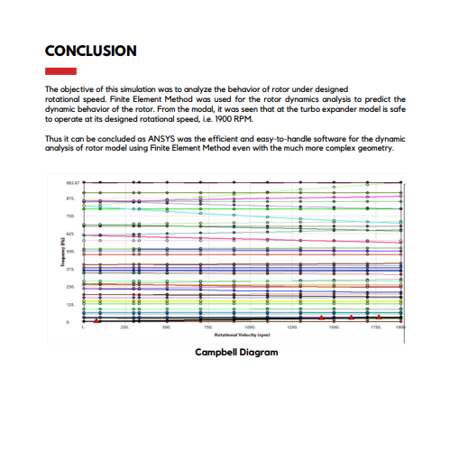
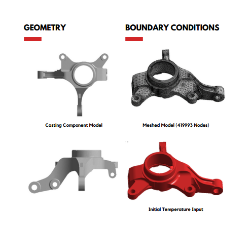
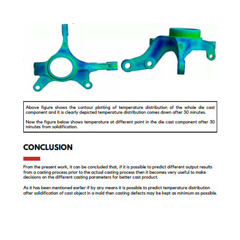
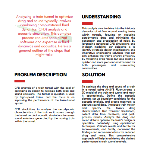
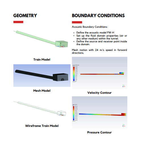
Products

Qantur

Ansys DME Component Libraries

Bring Mission and Systems Modeling Capabilities to Your Software Solutions

Ansys DME Component Libraries are a collection of development libraries well-suited for creating custom applications that benefit from web-first architectures.

Overview

Industry-proven Mission and Systems Modeling Software Development Libraries

Ansys DME Component Libraries are a collection of development libraries well-suited for creating custom desktop applications and web-first architectures. Available in Java and .NET, DME Component Libraries provide foundational mission and systems modeling capabilities in an architecture designed to scale efficiently. 

Features

Quick Specs

With Ansys DME Component Libraries, developers can directly benefit from decades of mission and system simulation expertise across many foundational capability areas.

Still have a question?

Real-time Data Support

Sensor Payloads

3D Visualization Engine and CZML Generation

Aircraft/Spacecraft Trajectory Design Tools

Geospatial Content Server (GCS) Integration

Accurate Global Geometry & Terrain

Spatial Analysis/Coverage

RF, Radar, and Navigation Systems

Platform Translational and Rotational Motion

Capabilities

DME Component Libraries Capabilities Ansys DME Component Libraries bring world-class mission and systems modeling to software developers

Ansys Mechanical creates an integrated platform that uses finite element analysis (FEA) for structural analysis. Mechanical is a dynamic environment that has a complete range of analysis tools, from preparing geometry for analysis to connecting additional physics for even greater fidelity. The intuitive and customizable user interface enables engineers of all levels to get answers fast and with confidence.

Ansys Workbench enables robust connection to commercial CAD tools, providing click button design point updates. Seamlessly integrated multiphysics capabilities are available with fluids and electrical solvers.

Capabilities

Key Features

Extend your custom software application development to include the following individual libraries capabilities

This library provides essential architectural elements and algorithms for modeling time, position, and orientation for accurate vehicle propagation, sensor modeling, and intervisibility calculations. Functionality includes:

  • Manipulation of scalars, points, axes, vectors, and reference frames
  • Precise platform positioning and orientation
  • High-fidelity, time-based intervisibility algorithm accounting for apparent motion, including light-time-delay and atmospheric refraction

Employs a highly optimized terrain caching implementation to account for terrain when computing altitudes and performing intervisibility and coverage computations. Utilize terrain and 3D data provided by a Geospatial Content Server.

Enables the computation of asset coverage over point sets, lines, regions, volumes, and dynamic platforms to measure effectiveness using:

  • Flexible gridding algorithms
  • Complex coverage definitions
  • Extensible figures of merit

Provides computational elements for analyzing RF signal transmission between moving or stationary platforms with configurable signal processing and propagation models.

This library extends the capabilities of the Communications Library to provide radar system performance analysis, including:

  • Attitude- dependent radar target cross- section modeling
  • Support for monostatic and bistatic radar systems
  • Multiple target signal returns and intended target identification
  • Metrics for dwell time, integrated signal-to-noise ratio, and probability of detection

Expands the capabilities of the Communications and Radar libraries with loss prediction over irregular terrain and seawater.

Model the GPS constellation using various data formats and configurable receivers to compute the navigational accuracy of terrestrial and spatial points. This library Includes algorithms for:

  • Dilution of Precision (DoP)
  • Navigational accuracy
  • Receiver Autonomous Integrity Monitoring (RAIM)

Using vehicle-specific characteristics, generate trajectories and attitudes for aircraft, ground vehicles, and ships. Functionality includes:

  • Pre-defined route procedures
  • Vehicle attitude modeling
  • Terrain-constrained procedures

Incorporate support for dynamically acquired data using the elements from this library. Integrate processing, visualization, and analysis for the development of decision support, situational awareness, and distributed simulation applications using:

  • Optimized one-point analysis
  • Data filtering and event processing
  • Software transactional memory system
  • Archiving and playback

Provides industry-recognized force model algorithms for numerically propagating satellite orbit state and covariance through any orbit regime including, LEO, MEO, GEO, HEO, and interplanetary missions. Includes impulsive and finite maneuver modeling capabilities.

Supplies architectural elements for computing vehicle trajectories where the manner of propagation changes with time:

  • Performing numerical propagation with arbitrary stopping conditions.
  • Solving for a trajectory by varying initial conditions and other propagation settings subject to arbitrary constraints on the motion and final conditions.

Propagate an aircraft through various maneuvers subject to flight phase performance models and wind effects. With defined aerodynamic and propulsion models, the aircraft’s orientation is determined by assuming coordinated flight.

DME Component Libraries contain robust simulation and systems modeling capabilities enhanced by a collection of visualization library options serving the needs of desktop applications and web-first designs:

  • Cesium Library: Visualize time-dynamic objects and analysis on a 3D globe or 2D map natively in a web browser. 
  • Insight3D Visualization Library (Windows only): Visualize time-dynamic objects and analysis with this embedded control in your custom desktop applications.

Geospatial Content Server provides a comprehensive enterprise solution for hosting, processing, serving, and analyzing terrain, imagery, and other heterogeneous 3D data.

  • Process and curate varied terrain data sources into a global unified global tileset for hosting 
  • Efficient streaming to client applications using open standards terrain runtime format, Quantized Mesh, avoiding vendor lock-in
  • 3D Tiles, Cesium’s open specification for streaming massive heterogeneous 3D geospatial datasets, is the format of choice for the Geospatial Content serve

Visioneering

Recent Events &
Webinars

Discover how engineering simulation is expanding across the entire product lifecycle.

Ansys Multiphysics
Conference

Join us on Saturday, June 10th, 2023, at 3 PM. The event will take place at Riverside Park, 123 River Lane, Springfield.

Blog

Future Tech Expo 2025

Join us on Saturday, June 10th, 2023, at 3 PM. The event will take place at Riverside Park, 123 River Lane, Springfield.

Blog

Innovative Simulations
Summit 2025

Join us on Saturday, June 10th, 2023, at 3 PM. The event will take place at Riverside Park, 123 River Lane, Springfield.

Innovative Simulations
Summit 2025

Join us on Saturday, June 10th, 2023, at 3 PM. The event will take place at Riverside Park, 123 River Lane, Springfield.

Ansys Multiphysics
Conference

Join us on Saturday, June 10th, 2023, at 3 PM. The event will take place at Riverside Park, 123 River Lane, Springfield.

Blog

Innovative Simulations
Summit 2025

Join us on Saturday, June 10th, 2023, at 3 PM. The event will take place at Riverside Park, 123 River Lane, Springfield.

Visioneering

Qantur Blogs &
Trends

Discover how engineering simulation is expanding across the entire product lifecycle. engineering / product design analysis by modeling & simulation.

Ansys Multiphysics Conferences

Introduction Mi tincidunt elit, id quisque ligula ac diam, amet. Vel etiam suspendisse morbi eleifend faucibus eget vestibulum felis. Dictum quis montes, sit sit. Tellus aliquam enim urna, etiam. Mauris

Read More »

Ansys Multiphysics Conferences

Introduction Mi tincidunt elit, id quisque ligula ac diam, amet. Vel etiam suspendisse morbi eleifend faucibus eget vestibulum felis. Dictum quis montes, sit sit. Tellus aliquam enim urna, etiam. Mauris

Read More »

Innovate

Breaking News & White Paper​

Discover how engineering simulation is expanding across the entire product lifecycle.

Smart Strategies for Large Structural Simulations

One way to gauge the progress of engineering simulation software is through the lens of size. Engineers today routinely run structural simulations with a few million degrees of freedom, and the largest commercial structural simulations have topped even 100 million degrees of freedom.

Introduction Mi tincidunt elit, id quisque ligula ac diam, amet. Vel etiam suspendisse morbi eleifend faucibus eget vestibulum felis. Dictum quis montes, sit sit. Tellus

Introduction Mi tincidunt elit, id quisque ligula ac diam, amet. Vel etiam suspendisse morbi eleifend faucibus eget vestibulum felis. Dictum quis montes, sit sit. Tellus

Introduction Mi tincidunt elit, id quisque ligula ac diam, amet. Vel etiam suspendisse morbi eleifend faucibus eget vestibulum felis. Dictum quis montes, sit sit. Tellus

Services

Qantur Case Studies

Qantur Technologies is a pioneer engineering simulations company based in Gurgaon –India. We provides expert Computer Aided Engineering – CAE consulting services for engineering / product design analysis by modeling & simulation.

Transform Ideas into Reality—Explore Our Simulation Solutions Today!

Partner with Us to Revolutionize Engineering Excellence!

Testimonials

Qantur Customer Testimonials

Fill out the form below, And you will get Case Study on Email